Singapore District and Planning Area
Following our first post about public and private housing types, this post is the second in our series to help the absolute beginner understand the Singapore property market. We’ll be discussing the different districts and planning areas. You often hear about districts 9, 10 and 11 being the “hot” areas, but what exactly do they refer to? And how about the other districts? Read on to find out.
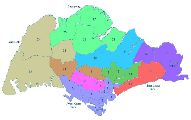
While there are no longer any official district codes used in Singapore, many people will often refer to a property being in a specific district when buying or renting. These codes were originally used for the postal districts, but were replaced by the 6-digit postal codes a number of years ago. Here are the general areas the district codes refer to:
01 – Raffles Place, Cecil, Marina, People’s Park
02 – Anson, Tanjong Pagar
03 – Queenstown, Tiong Bahru, Alexandra
04 – Telok Blangah, Harbourfront, Sentosa, Keppel, Mount Faber
05 – Pasir Panjang, Buona Vista, Dover, West Coast, Clementi New Town
06 – High Street, Beach Road, City Hall
07 – Middle Road, Golden Mile, Bugis, Rochor
08 – Little India, Farrer Park, Serangoon Road
09 – Orchard, Cairnhill, River Valley
10 – Ardmore, Bukit Timah, Holland Road, Tanglin
11 – Watten Estate, Newton, Novena, Thomson
12 – Balestier, Toa Payoh, Serangoon
13 – Macpherson, Braddell, Potong Pasir
14 – Geylang, Paya Lebar, Eunos, Kembangan
15 – Katong, Joo Chiat, Amber Road, Marine Parade, Tanjong Rhu, Meyer
16 – Bedok, Upper East Coast, Eastwood, Kew Drive, Chai Chee, Siglap
17 – Loyang, Changi
18 – Tampines, Pasir Ris, Simei
19 – Serangoon Garden, Hougang, Punggol, Sengkang
20 – Bishan, Ang Mo Kio, Braddell
21 – Upper Bukit Timah, Ulu Pandan
22 – Jurong, Boon Lay, Tuas, Lakeside
23 – Hillview, Dairy Farm, Bukit Panjang, Choa Chu Kang, Bukit Batok
24 – Lim Chu Kang
25 – Kranji, Woodgrove, Woodlands
26 – Upper Thomson, Springleaf
27 – Yishun, Sembawang, Admiralty
28 – Seletar, Yio Chu Kang
There are a total of 28 districts, but you’ll mostly hear references to districts 9 (Orchard, River Valley), 10 (Bukit Timah) and 11 (Newton, Novena) as the traditional high end housing areas, and to districts 1 (Marina Bay), 2 (Tanjong Pagar) and 4 (Harbourfront, Sentosa) as the new up-and-coming luxury areas. For a more relaxed and lower density lifestyle districts 14 (Eunos, Kembangan), 15 (Katong, Marine Parade, Tanjong Rhu) and 16 (Upper East Coast, Siglap), broadly known as East Coast, are also popular.
“District creep”
Do note that there is some ambiguity around the borders of these districts so one area could cover two or more districts. In fact in recent years as the property market has heated up I’ve noticed a phenomenon I call “district creep”, where properties in a less prestigious area are marketed as being in a more prestigious one nearby.
So for example properties in Newton are advertised as being in Orchard, properties in Novena as Newton, and those in Balestier as being in Novena. This is probably a result of developers wanting to push up the prices they can charge by increasing the stature of their development, and of status conscious Singaporeans wanting to showcase their home as being in a more prestigious district but not being able to afford one!
Urban Planning Areas – The Master Plan and Concept Plan
Distinct from the concept of districts that are commonly used in the property market, the Urban Redevelopment Authority (URA) has divided Singapore into 55 urban planning areas, which are organized into five regions – Central, East, North, North-East and West. The URA puts together two urban plans, the Concept Plan and Master Plan, which can significantly affect the value of the real estate when any changes to the plan take place.
The Concept Plan is the long term strategic land use plan which guides Singapore’s development over a forty to fifty year period. Reviewed every ten years, it provides for sufficient land to meet long-term population, economic and quality of life goals. The last Concept Plan Review was in 2001, and the next one will be completed in 2011.
The Master Plan is the medium term statutory land use plan which guides Singapore’s development in over a ten to fifteen year period. Reviewed every five years, it renders the broad strategies of the Concept Plan into detailed plans that show the permissible land use and density for developments in Singapore. The last Master Plan was in 2008, and the next one will be completed in 2013.
source: http://www.propwise.sg/singapore-property-beginners-guide-part-2-districts-and-planning-areas/
Last modified: